Caledon Trailway Guide: Tips for Hiking this Ontario Rail Trail
Within the Town of Caledon, there are over 260 kilometres of trails. One of the top things to do in Caledon is hike. A top trail is the Caledon Trailway! This multi-use trail runs 35 kilometres across Peel Region, from Terra Cotta to Highway 9, and ends in New Tecumseth. So, if you’re looking for awesome hiking trails in Ontario then add the Caledon Trailway to your list.
I completed the trail myself! With so many charming Ontario small towns and interesting sights along the way, I highly recommend it! If you’re thinking about tackling it, I’ve put together the ultimate Caledon Trailway guide. This guide has everything you need to know about the Caledon Trailway, including distances, where to park, stops along the path, and where to eat!
The Caledon Trailway
The trail follows an old rail line that was built in 1877. It’s 35 kilometres in length. Plus, a portion of it is even part of the Trans Canada Trail. As a rail trail, it is relatively flat and accessible, making it a great option for both young and old, as well as families with strollers.
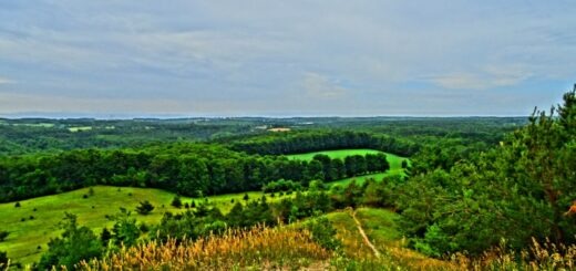
Along the trail, you’ll encounter scenic woodlands, cross rivers and country roads, as well as pass through small towns and tranquil Caledon farms. You’ll also navigate some of Ontario’s incredible natural features along the Caledon rail trail, like the Humber and Credit Rivers, the Oak Ridges Moraine, and the Niagara Escarpment.
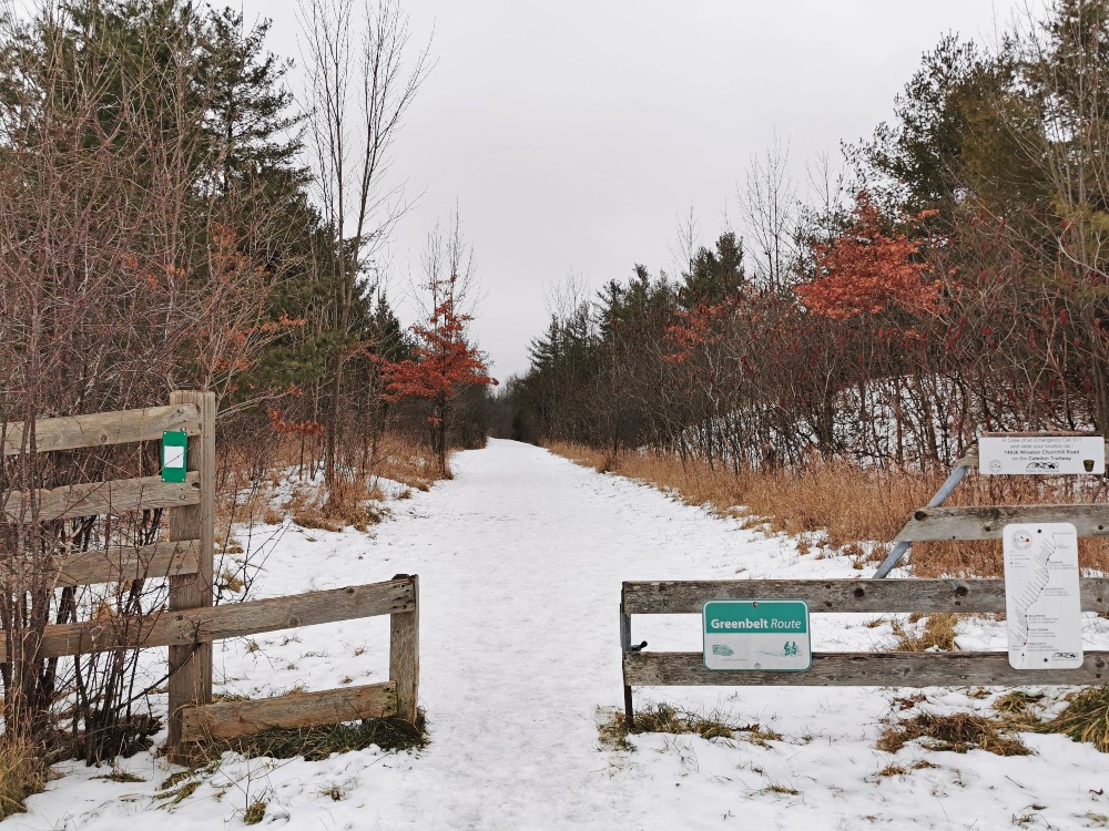
There are many ways to traverse the trail. You can travel it via horseback, foot, or by bike. During the summer months, it’s a popular Caledon bike trail. An added bonus is its part of the Greenbelt Cycling Route.
In this guide, I’ll break down the Trailway into four sections. You’ll find all the details including where to park, the length, the time it will roughly take to complete (on foot), as well as what you’ll see in each section. Plus, with so many great Caledon restaurants, I’ll include where to eat and drink along the way.
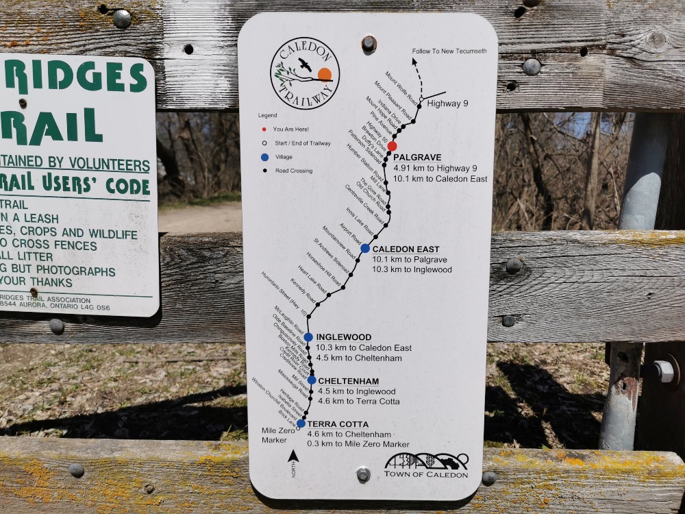
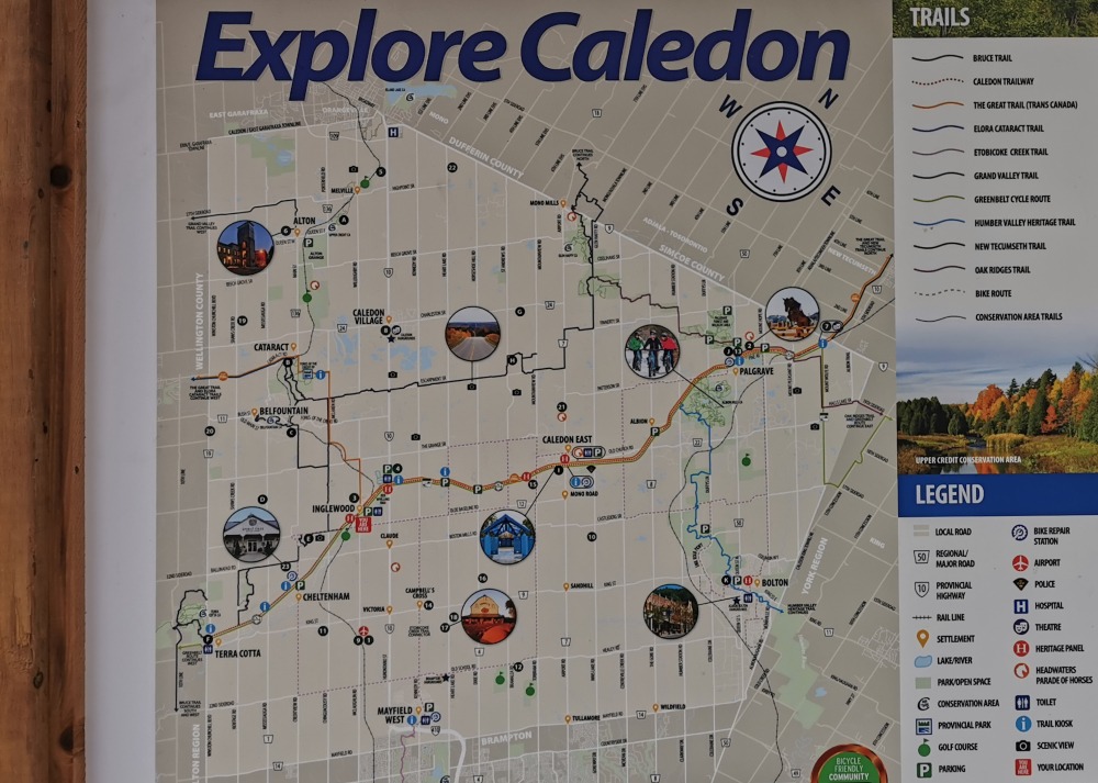
One great addition to the Caledon Trailway is the marker maps. You’ll find these at the beginning of every section, as well as at most road crossings along the trail. The markers show the distance between each section. Each main town that the trail runs through is also highlighted, along with each road crossing.
Trailhead to Inglewood
The Caledon Trailway start of the trail is located at the end of Brick Lane, a short steep road, in the village of Terra Cotta. At mile zero of the Trailway it also links up with the one of the Bruce Trail side trails, the Terra Cotta Side Trail.
From the Caledon Trailway trailhead to Inglewood, it is 9.1 kilometres and takes approximately two and a half hours. Timing all depends on your type of travel, if you’re cycling it will obviously be completed in a shorter timeframe. But for this post I’m sharing times for hiking the Caledon Trailway.
A wonderful gem to stop at before you begin is the Terra Cotta Country Store. This seasonal shop and bakery serves a variety of baked goods as well as ice cream and beverages.
As with all of the Caledon Trailway sections, the trail takes you through quiet forests, over bridges, and across country roads. But the main attraction of the first portion of the Trailway is the Caledon Brick Words.
The Cheltenham Brick Works, as they are also known, is a historic site found about a third your way through this section of the trail. The Brick Works is located on Mississauga Road and operated from 1914 to 1958. It’s sadly now abandoned and not well preserved. The area is completed fenced off but you can view it from the trail. Five out of the original six brick chimneys and a few other buildings are all that remain.
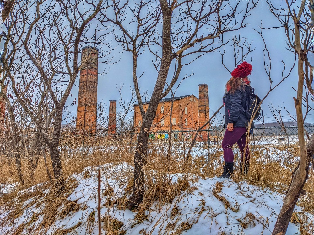
Fun Fact: The Cheltenham Brick Works was the first brickyard in Canada to mass produce and ship bricks both nationally and internationally by both truck and rail.
Just as you enter into Inglewood, you’ll find a few signs. These plaques share interesting information about the community, its early days, and the railway junction. Be sure to read these before you take a wander through town. You’ll learn about the people and buildings, some of which are still standing, that helped make Inglewood what it is today.
Trailhead to Inglewood Information
Length & Time: 9.1 kilometres and roughly 2.5 – 3 hours
Where to park: End of Brick Lane in Terra Cotta (Please note: there is minimal parking)
Where to eat & drink: – Terra Cotta Country Store or Coywolf Coffee and Bike Shop Café in Inglewood

Inglewood to Caledon East
The Inglewood to Caledon East section of the Trailway is a winding stretch that is also part of the Trans Canada Trail. This second portion of the Caledon Trailway is ten kilometres in length and takes roughly two and a half hours.
A great place to pop into before you start this section is Coywolf Coffee. Grab yourself a coffee and one of their famous apple fritters to help fuel your hike!
You’ll find the trail starting just past the small parking lot along the train tracks running through Inglewood. The trail is flanked on both sides with towering trees and forest tracks along much of this section. It also goes through Ken Whillians Resource Management Area and links up with the Credit Valley Trail.
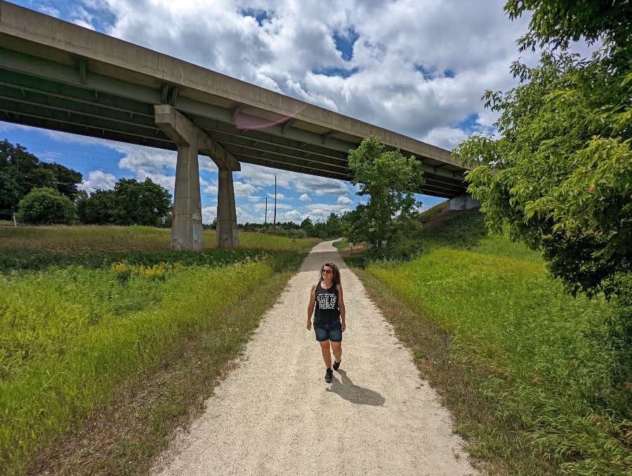
After the park you’ll be met with a large bridge that takes you up and over Hurontario Street (aka Highway 10).
Fun fact: Hurontario Street runs from Lake Ontario in Mississauga to Lake Huron in Collingwood. However, it makes a lot of turns and has various names throughout the different counties.
There are actually a few bridges along this stretch of trail. One of which, the Cardwell Junction is no longer. However, you’ll find a plaque sharing information about how this was the site of the crossing of the Toronto Grey and Bruce Railway that went over the tracks of the Hamilton and Northwestern Railway. All that remains now are the embankments and the concrete supports.
Tip: Hike to the top of the embankment to get a bird’s eye view of the trail!

The last main attraction of the Inglewood to Caledon East section is the Trans Canada Trail Pavilion that’s located just before you hit town. This brilliant blue structure has photos of the Great Trail, quotes, and names of some of many donors that helped create it.
Inglewood to Caledon East Information
Length & Time: 10.3 kilometres and roughly 2.5 – 3 hours
Where to park: 15605 McLaughlin Road #15601 (alternative parking can be found at the Llyod Wilson Centennial Arena, this is also where you should park in the winter)
Where to eat & drink: – Coywolf Coffee and Bike Shop Café in Inglewood or Four Corners Bakery in Caledon East

Caledon East to Palgrave
The Caledon East to Palgrave section of the Trailway is a tranquil and scenic stretch. This third portion of the Caledon Trailway is ten kilometres in length and takes roughly two and a half hours.
Starting in charming Caledon East, you’ll find the trailhead just south of the Four Corners Bakery. The Bakery is a great place to start your day with a solid cup of coffee and one of their delicious baked goods.
Shortly after the trailhead you’ll find another trail heading south. This boardwalk trail is short and takes you through the marsh and over to Mountcrest Road. And just a few short steps further along, on your left, you’ll find a cute rainbow bench!
Related Post: 25+ Amazing Boardwalk Trails in Ontario
Along the Caledon East to Palgrave section, you’ll find a variety of ponds, some small and others large. They are wonderful areas for spotting wildlife, especially the wealth of birds that migrate through during the spring. I saw a few warblers and many other species! About halfway through you’ll come to a large pond and marshy area. It’s a lovely scenic spot to sit and birdwatch or even enjoy a snack. There’s even a bench!

Other notable sights in this section of the Caledon Trailway include the Caledon Trailway Trestle Bridge and Palgrave Stationlands Park. The trail also skirts around Albion Hills Conservation Park.
Be sure to reward yourself after your Caledon Trailway hike with a visit to Caledon Hills Brewery! Located in an 1882 church, the brewery’s pub has all the charm of an old church and a Munich beer hall! Grab some grub and a pint!
Caledon East to Palgrave Information
Length & Time: 10.1 kilometres and roughly 2.5 hours
Where to park: Street parking along Airport Road through town or at Caledon Town Hall
Where to eat & drink: Four Corners Bakery in Caledon East and Caledon Hills Brewing Company

Palgrave to Tottenham
The last section of the Caledon Trailway path is from Palgrave to Highway 9. It starts on the east side of Highway 50, just south of town. You’ll find the trailhead right next to the Palgrave time clock tower.
This portion of the trail is also part of the Oak Ridges Moraine Trail and Trans Canada Trail. At the beginning of the trail, you’ll find a Caledon Trailway map showing where each trail goes after the end of the trailway.
There are few highlights along the trail from Palgrave to the end. The first is a scenic circular pond to the south just after you start this section. You’ll also pass by the Caledon Equestrian Park, so keep an eye out for horse dung and riders along the trail.
The trail also passes by Palgrave Park. If you are in need of a bathroom then follow the trail to the north that takes you into the park. During spring through fall, the park has accessible facilities. You’ll find a small blue sign along the trailway. Follow the trail into the park and to the left, behind the baseball home plate is a small building where you’ll find them.
After roughly an hour you’ll find yourself at the end of the Caledon Trailway. It terminates underneath Highway 9, with sweeping views all around and of the bridge. This is where Caledon meets Simcoe County.
I highly recommend tacking on another approximately 5 km and ending your hike in the town of Tottenham. While the trailway ends the Trans Canada Trail continues on. Along this section of trail, you’ll pass through dense cedar forests and along the edges of Tottenham Conservation Area. There are plenty of little lookouts over the large Tottenham Pond. The trail ends at the gate to the South Simcoe Railway.
Tottenham is home to a few places to grab a bite to eat. I highly recommend A Taste of Freedom! Set in a historic building, it’s filled with stunning dining rooms and a massive back patio. It’s a great place to eat and indulge in a celebratory drink!

Palgrave to Tottenham Information
Length & Time: 4.91 kilometres to end of Caledon Trailway at Highway 9. It takes roughly an hour. Or you can continue on the Trans Canada Trail and end in Tottenham. Highway 9 to Tottenham is roughly an hour.
Where to park: Street Parking in Palgrave along Highway 50 or at Palgrave Stationlands Park.
Where to eat & drink: River Ridge Café in Palgrave and A Taste of Freedom in Tottenham.
Frequently Asked Questions about the Caledon Trailway
When planning your Caledon Trailway hike there are many things to consider. So, I’ve laid out all the essential information about the Caledon Trailway below, including where it is, the best time to hike it, and more!
What is it known for? The Trailway is known as a popular bicycle and walking trail through Caledon. It runs along the abandoned CN Rail Line that once served the Grand Trunk Railway System in the later 1800s.
Where is it? The Caledon Trail runs through Caledon from Terra Cotta to Tottenham. The trail is located in the northern portion of Peel Region.
Where to park along the Trail? Caledon Trailway parking can be found at numerous areas along the path. Most road crossings offer limited parking. But you can find larger parking areas at: Gore Road north of Old Church Road, Caledon East (Town facilities lots on Old Church Road), Ken Whillans RMA on Highway 10, east side of McLaughlin Road in Inglewood, and on Winston Churchill Blvd near Terra Cotta.
TIP: It’s a great idea to hike with a partner. That way you can each park at one end of the trail section, so you don’t have to double back.
Best time to hike the Trail? There is no bad time to hike the Trailway! However, while you can still hike it in the winter, it is not maintained during the winter months. But if you’re looking for the best time to hike the Caledon Trailway, I’d say spring and fall. The temperatures are comfortable, especially with may areas fully open to the sun. And, you can easily hike and ride your bike along it during these seasons.
Best part of Caledon Trailway? Each section of the trail has something unique to offer. If you’re looking for history, then the first portion is ideal. If you’re looking to do some birding, then the third portion is ideal.
Top Attractions – As mentioned, there are a ton of attractions along the Caledon Trailway. Some of which are: Caledon Brick Works, Trans Canada Trail Pavilion, and various bridges.
Rules of the Caledon Trailway
- For those cycling, you are to give horses the right of way
- Cyclist should also alert others when approaching, with a bell or verbally
- Dogs must be leashed at all times and you are to pick up their poop
- Respect private property and do not trespass
Hiking Caledon Trailway Recap
I highly recommend hiking the Caledon Trailway! The trail is easy for all abilities and can be hiked all year long. Plus, the trail is relatively quiet, especially during the week! And you can reward yourself after every hike by eating at the many cafes and restaurants found in the cute small towns along the trail.
It was so nice to see the trail in different seasons. We started in the dead of winter and ended in the heat of summer, and it was awesome! Summer on the trail means you’ll be met with plenty of wildflowers lining the pathway as well as lush growth. However, every season will reward you with some kind of magic!
Do you have any questions about hiking the Caledon Trailway?
PIN IMAGE FOR LATER REFERENCE!