+20 Best Hiking Trails in Canada from Coast to Coast
True north strong and free! Canada is vast in its size and natural beauty. With a wealth of reasons to visit Canada, one of the top reasons is to experience its diverse landscapes. And the best way to do that is getting out on any number the top hiking trails in Canada, found across the country. But with a country as big as Canada, spanning nearly 10 million square kilometres, where do you even begin?
I’ve pulled together a list, with the help of my fellow outdoor enthusiast travel bloggers, of the top hiking trails in Canada to help get you started. From challenging trails that will take you to the tops of mountains to casual hikes through beautiful scenery, these top Canadian hikes will inspire you to get outdoors and explore this incredible country.
So lace up your hiking boots, grab your water bottle, and hit the trails!
 The Great Trail
Canada is literally home to The Great Trail. While it wasn’t always ‘great’ the vision of it always was. Back in 1992, a not-for-profit organization created the Trans Canada Trail. They dreamed of creating a trail that would span Canada. No easy feat being the second largest country. And after 25 years, in 2017 for Canada’s 150th birthday, The Great Trail was born.
Starting near St. John’s Newfoundland, going through towns, across rivers, and over mountains, The Great Trail finishes on Vancouver Island. Connecting 15,000 communities and covering 24,000 kilometres, The Great Trail is not only one of the top hiking trails in Canada, it is the longest trail in the world!
While very few have actually completed it, the trail is said to take around two years to complete. And if you plan on hiking it don’t worry about carrying a wearisome map, there’s a mobile app to help take you across Canada’s Great Trail
INTERESTING INFO: 4 out of 5 Canadians live within 30 minutes of The Great Trail
Related Post: 5 Ways to Reduce Your Footprint on Nature
20 Best Hiking Trails in Canada

British Columbia Hiking Trails
Wedgemount Lake Trail in British Columbia
Situated just a few kilometres outside of Whistler the Wedgemount Lake Trail was one of the most challenging but beautiful hikes that we did in this area. Hiking up there and camping out next to this glacial fed lake was just mind-blowing, and an experience we will never forget! The picture tells it all as it really was that breathtaking shade of blue!
The 7km trail that we followed 1200m all the way to the top was pretty tough going, especially with all of our overnight gear and a moderate scramble near the end! It took us about 4 hours in total and about 3 hours to get back down again the next day, this can also be done as a day hike & we’re guessing with less gear it would be a lot quicker! There are camping spots and a hut up there that can be booked through the BC parks website. We’d also advise taking plenty of warm gear, food and water with you if you are planning on taking this hike on!
If adventure is your thing then this wild camping experience is definitely the one for you!
– recommended by Kelly & Adam from Destination Addict
Make sure you have everything you need for a great hike! Here’s your hiking must-haves packing list!

Iceline Trail in British Columbia
Located in Yoho National Park in British Columbia, the Iceline Trail is one of Canada’s most spectacular hikes. A 17+ kilometre loop, it’s a pretty long day hike, but an extremely rewarding one, with views that span several incredible views of the Canadian Rockies. A short drive from Banff National Park, the Iceline trail is a moderate difficulty hike with a trail that runs past waterfalls, through evergreen forests, and high above to stunning panoramic viewpoints. From the highest elevations of the trail, hikers can see out to Yoho Glacier and across the way to Takkakaw falls.
You’ll park at Takkakaw Falls parking lot then begin your hike, which has several variations you can take. However, many people opt to ascend above the treeline first, taking in the incredible views before descending into the forest and the rest of the loop. There are also some backcountry camping options near the trail that you can explore if you’d like to extend your hike over the course of a few days or explore other trails in the vicinity.
– recommended by Kay from Jet Farer

First Peak of Stawamus Chief in British Columbia
Along the famous Sea to Sky Highway, which connects Vancouver and Whistler you will find Stawamus Chief; a 700m high granite dome that towers over the nearby Howe Sound. Stawamus Chief is divided in three distinct summits, all with epic views over the surrounding landscapes. On our British Columbia road trip from Vancouver to Whistler we decided to hike at Stawamus Chief to break up our drive, since we were short on time we only did the first summit, also called First Peak.
This hike is advertised online as “intermediate” so only go for it if you’re up for a challenge. I consider myself a relatively fit person but have to admit that I found the First Peak very tough. The round-trip to the summit of First Peak is 4km, however, it is very steep in certain parts so allow yourself 2-3 hours to do it. The first part is the steepest and toughest; you will walk up alongside Shannon Falls, a beautiful waterfall but be careful since the spray from the waterfall can make the steps slippery! There are markers that indicate the route, however the trail itself isn’t always marked clearly and you will often have to climb over logs or rocks to proceed. In certain areas there are chains and ladders to help you climb up. Once you get to the top though, the view is well worth the hike!
– recommended by Greta from Greta’s Travels

Wild Pacific Trail in British Columbia
The Wild Pacific Trail can be found on the Southside of Vancouver Island, in the tiny village of Ucluelet. It’s a relatively short and easy trail, only 10 kilometres, but the views along the way are absolutely stunning. We hiked the trail in the rain, but even the weather couldn’t dampen our high spirits, what an amazing and rugged coastline!
The trail consists of several parts, you can choose to hike them all on the same day or split them over several days. Highlights are the Ancient Cedars, the Artist Loops and the Amphitrite Point Lighthouse. While this may not be the most picturesque lighthouse you’ve ever seen, it’s certainly one of the strongest. It has to withstand the pounding waves during the frequent storms which occur in this part of Canada.
Please be aware you may encounter bears or wolves on the trail. On the trail you’ll find information signs telling you what to do when you come across one of these magnificent but potentially dangerous creatures, so read them before you set out to hike this beautiful trail!
– recommended by Lotte from Phenomenal Globe
Alberta Hiking Trails

Ha Ling Peak Trail in Alberta
Hiking Ha Ling peak is probably more on the difficulty scale as far as hikes go. It is not long only about 3 hours to the top at a reasonable fitness level but it is steep the whole way and if there is snow you can add a little longer to that especially if you don’t have the right gear. If it’s winter, crampons are highly recommended. Once you clear the tree line you have incredible views of the rundles and dozens of other peaks. Once at the top you have breath-taking views of Canmore and the entire surrounding area as far as you can see, providing the weather is co-operative. It’s literally an endless sea of mountains. Remember to take warm clothes as winds are often brutal at the summit. We copped close to 100km gusts. All in all one of the easiest, most accessible and rewarding hikes in Canmore.
– recommended by Dane from Holiday from Where

Skyline Trail in Alberta
The Skyline Trail in Jasper National park was the first hike I did after arriving in the Rocky Mountains, and certainly one of the most spectacular experiences I had. The trail stretches for almost 45 kilometres; therefore, you need to break it down into two days and spend the night in one of the campgrounds. I was there in July, but it was absolutely freezing in the night – make sure to bring some warm clothes, I didn’t! However, the views were certainly worth it. With most of the trail being above the tree line, you have fantastic views of the landscape. The toughest part for me was reaching “The Notch” at the beginning of the second day since it was super windy and cold! After arriving back in town, my feet were actually full of blisters and I couldn’t wait to get warm food and a hot shower, but the incredible landscape and the views were worth it!
– recommended by Patrick from German Backpacker

Lake Agnes Teahouse Trail in Alberta
If you’re visiting Banff National Park in Alberta, chances are you’ve realized there’s no such thing as a bad hike. But perhaps our favourite is just to the right of one of the most photographed places in Banff: Lake Louise. If you take the Lake Agnes trail (or the Teahouse Trail), you’ll find yourself hiking up past stunning, ever-higher viewpoints on Lake Louise. Pause halfway at Mirror Lake for a picnic (mind the squirrels!), enjoy at least one lovely waterfall with a view, and finally hoof it up a steep wooden staircase to Lake Agnes.
Surrounded by mountains and a glacier, serene Lake Agnes takes on shades of blue, green, and even gold – if you visit in fall when the larches turn gold. Even better, this lake plays host to an electricity-less teahouse, which has been on site for over 100 years. With hundreds of teas and several yummy snacks, make sure you bring cash so you can enjoy the fruits of your labour.
Got energy to spare? Take the Big Beehive trail around Lake Agnes, and hike a steep, switchbacking, challenging trail up Big Beehive for jaw-dropping views of Lake Louise and the surrounding countryside that are even better than the gondola.
– recommended by Luke & Meagan from Two Restless Homebodies
Yukon Territory Hiking Trails

Grizzly Lake Trail in Yukon
Surrounded by intensely jagged mountains, Grizzly Lake is a destination like no other in Yukon Territory. The 12km trail follows a mountainous ridge in Tombstone Territorial Park, providing sweeping views of the valley and seemingly barren tundra beyond. Ascend the ridge and then travel across scree-covered slopes, through alpine meadows (say hi to the marmots) and over a few boulder fields before arriving at the lakeside campground. In a landscape devoid of trees, glimpses of the looming Tombstone Mountains and glittering little lake beneath can be seen almost the whole way along. This is one hike where the journey is definitely as epic as the final destination.
The Grizzly Lake Trail may only be 12km one way but it is undoubtedly a fairly intensive hike. The good news is that the midnight sun enables long hiking days, so there’s no rush. If you can’t get a camping reservation (essential in July and August) or haven’t got overnight gear, no problem. Do part of the trail as a day hike. The best views are seen about 4km from the parking lot. Most of the early trail distance features steep elevation gain so be sure to bring your hiking poles!
– recommended by Gemma from Off Track Travel

Sheep Creek Trail in Yukon Territory
Kluane National Park in the Yukon’s southwest is a land of extremes. In the summer months, it’s an absolutely breathtaking place for hiking whilst in the winter the park becomes a sprawling wilderness of ice and snow. One of several day hike options, Sheep Creek Trail is a stunning 10km return hike with a moderate elevation gain (430 m).
The trail starts in the forest at the bottom of Sheep Mountain (Tachäl Dhäl) along the southern shores of Kluane Lake, making it a good choice for less than perfect weather conditions. It then winds its way along the southwestern slopes, following an old mining track above Sheep Creek. As it climbs above the treeline, you get spectacular views of the Slims River Valley (Ä’äy Chù) and can even catch glimpses of Kaskawulsh Glacier in the distance.
If you’re there in the fall, the foliage will be seriously radiant and golden. You might also be lucky enough to spot some Dall sheep – just don’t approach, they’re shy and easily disturbed. If you’re keen and experienced, you could extend the hike by continuing onto the Tachäl Dhäl Ridge route (6km return) but it’s an unmarked trail from the 5km marker so you’ll need to know what you’re doing.
– recommended by Kati from Adventures in Queensland & Beyond
Related Post: Top 10 Hiking Trails Across the Globe
Northwest Territories Hiking Trails
South Loop Trail in Northwest Territories
Canada’s Northwest Territories are vast in size and beauty. And one of the top hiking trails in Canada can be found in Wood Buffalo National Park, Canada’s largest National Park. South Loop is a 9 kilometre loop trail that will take you by the salt flats and strange mineral formations at Grosbeak Lake. Another of the big draws to this trail is the wealth of wildlife in the Park. Home to thousands of free-roaming bison as well as endangered whooping cranes, you’ll never be alone on the trail.
It’s also a great place to camp overnight as the Park is the largest dark sky preserve in the world and a fabulous place to see the aurora borealis.
INTERESTING INFO: Wood Buffalo National Park is the second-largest park in the world and bigger than Switzerland!
Saskatchewan Hiking Trails

70 Mile Butte Trail in Saskatchewan
In a province known for being flat, I was surprised to find this stunning vantage point from the top of 70 Mile Butte trail in Grasslands National Park. Located in Southern Saskatchewan, Grasslands National Park contains the most intact and greatest example of the remaining native prairie in Canada and is also home to some of the rarest wildlife, such as the Black-footed Ferret and the Black-tailed Prairie Dog. This off-the-beaten-track national park also offers a number of beautiful hikes, including 70 Mile Butte, one of the highest points in the park. We came here for sunset and it was truly an unforgettable experience. There’s also a lot of Rattlesnake-warning signs, which added to the adventure. This 4.1 km loop is ranked as difficult but I would give it more of a moderate rating. The only difficulty would be the climb but if you’re reasonably fit, I don’t see how this trail would be much of a problem. Once at the top, you can see the vast stunning landscape surrounding the place, including both the rolling prairie farmland and the wildland it once was. 4.1 KM Loop
– recommended by Matthew from Must Do Canada
Related Post: Top 10 Tips for Day Hikes
Manitoba Hiking Trails
Spirit Sands/Devil’s Punch Bowl Trail in Manitoba
Too many people pass over Manitoba and it’s a shame. You’d be utterly surprised by all the province has to offer, including hiking trails. One of Manitoba’s best trails is Spirit Sands/Devil’s Punch Bowl Trail in Spruce Woods Provincial Park, about a 2 ½ hour drive from Winnipeg. This is actually two separate trails with a connecting trail and is often referred to as one trail. The best time to hike the trail is in the summer, early in the morning before it gets too hot.
Along the Spirit Sands/Devil’s Punch Bowl Trail you’ll find a variety of landscapes. From wooden staircases taking you to beautiful views of the area to hiking through the incredible desert-like atmosphere and sand dunes that are littered with perfect yellow flowers, as well as woodland and meadow this trail has it all. And the Devil’s Punch Bowl is an awesome sight. Formed by an underground stream where sand slides into the 45 meter depression and disappears, the pond (dubbed the Devil’s Punch Bowl) is a remarkable mix of blue-green water. The trail takes approximately 2 to 3 hours depending on your pace and how many stops you take for photos.
Ontario Hiking Trails
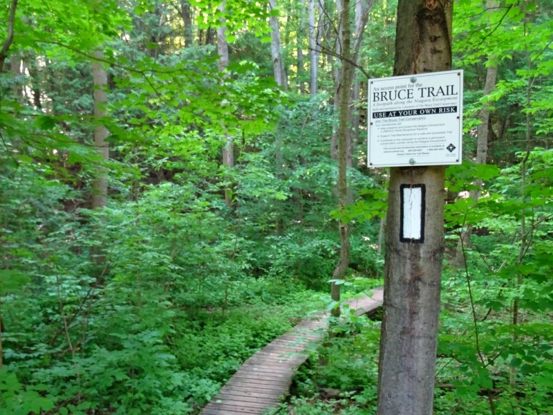
Bruce Trail in Ontario
The Bruce Trail is easily Ontario’s most popular trail. And there are hundreds of reasons why it’s also one of the top hiking trails in Canada. The Bruce Trail is the oldest marked trail in Canada and is used by over 400,000 people every year. Spanning Southern Ontario, from Niagara to Tobermory, it runs along the Niagara Escarpment which is a UNESCO World Biosphere Reserve. The Niagara Escarpment brings incredible landscapes together, from hiking through canyons and over crevices to standing atop cliffs with magnificent views and beholding stunning waterfalls.
Not only is the Bruce Trail 895 kilometres in length but it also has over 400 kilometres of associated side trails to discover. And while many, including myself, enjoy hiking segments of the Bruce Trail throughout the year, you can complete it end to end in 30 days.
INTERESTING INFO: Approximately half the trail is on private property. (Big THANKS to these gracious landowners!)
– recommended by ME!
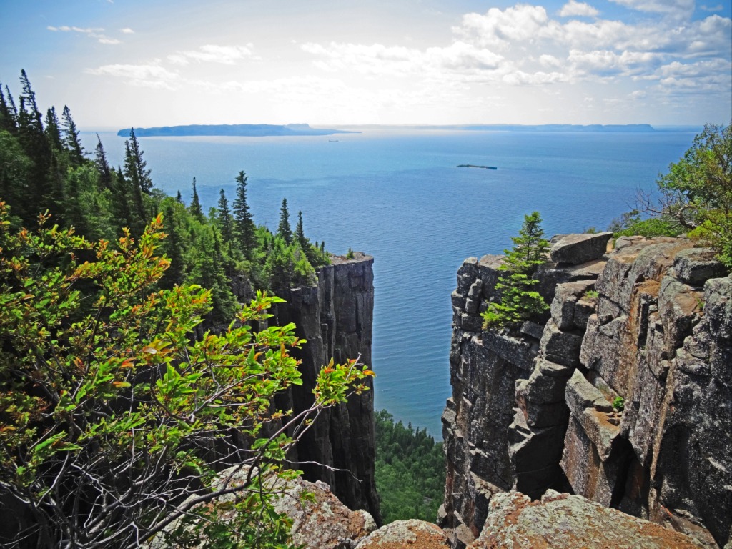
Top of the Giant Trail in Ontario
For me, one of the top hiking trails in Canada is Ontario’s Top of the Giant Trail. Located in Northern Ontario, just outside Thunder Bay, in Sleeping Giant Provincial Park, the Top of the Giant Trail is an epic trail. This is a challenging trail at times and at 22 kilometres is a great day hike that will take you roughly 6 hours (longer if you stop to enjoy the views more). To get to the trail you have to hike part of the Kabeyun Trail, starting from the South Kabeyun Trailhead, then to the Talus Lake Trail which will lead you to the Top of the Giant Trail.
The trail takes you past picturesque Lake Superior, through woodland, and then up a steep trail. The Top of the Giant Trail will reward you with not one but multiple awesome views. But the best is at the trail’s end. Here you’ll find yourself standing atop one of Ontario’s highest cliffs, over 600 feet above Lake Superior, that’s known as The Chimney.
INTERESTING INFO: Sleeping Giant Provincial Park is on the Sibley Peninsula that juts into Lake Superior, and from many vantage points the southern end of the park looks like a giant laying down – hence the name.
– recommended by ME!

Dundas Peak in Ontario
Dundas Peak is one of the most popular day hikes out of Toronto. It’s located close to Hamilton which is about a 1 hour drive outside of Toronto. The trail starts out with a couple of steps (maybe like 150-200 meters) before you get to the viewing platform for Tews Falls (which is gorgeous!). You then continue the hike which has a 110 meter elevation gain until you get to Dundas Peak. The entire hike is about 3.9 km in total so it’s easily done as a half day type of activity. It takes you past Tews Falls, in through the forest and up to the peak. The peak is off a cliff so you need to be careful when stepping close to the edge. You’ve got two options for views once you get up there. The one is straight into the forest (which is amazing in the fall time!). The other one is off towards town. That view is nice because it’s got a really long train track running through it and we had a great time watching the train come from really far away and drive past us!
– recommended by Liliane from My Toronto My World
Related Post: Top 10 Hiking Trails in Europe
Quebec Hiking Trails

Le Sentier des Caps de Charlevoix Trail in Quebec
Le Sentier des Caps de Charlevoix is the perfect trail if you love forest walking and dramatic views. Most people start their Le Sentier des Caps hiking from Saint-Tite-des-Caps parking and you might do that as well, there is even a bus from Quebec City to bring you there. I used the town as my last stop and got a bus from there back to Quebec City.
The basic route requires about four days but I took my time. I had eight days to fill so I made a loop at the northern end of the trail and went back, retracing parts of my steps. Throughout the trail, you walk mostly on difficult, rough paths with a lot of rocks, boulders, and roots. Sometimes there are more challenging situations with ropes or chains provided to help a bit. This gives a great sense of challenge and adventure – this trail is anything but boring! Every now and then the trail opens to a stunning view over the St. Lawrence River, a truly jaw-dropping vista.
A few tips: camping is on platforms, not suitable for non-free-standing tents. Pack a good power bank – there is no place to charge your devices. Pay for your accommodations in Saint-Tite-des-Caps (campsite/hut).
– recommended by Ioanna from A Woman Afoot
New Brunswick Hiking Trails

Fundy Footpath in New Brunswick
Not only is New Brunswick’s Fundy Footpath one of the top hiking trails in Canada but probably one of the top on the east coast. This 42 kilometre trail takes you along the coast of the Bay of Fundy, known for having the highest tides in the world. The Fundy Footpath is home to some incredible sights. You’ll discover everything from secluded beaches to outstanding views from the many lookout points along the trail and stand atop over 300 foot sea cliffs to a 50 foot waterfall.
Nova Scotia Hiking Trails
Skyline Trail in Nova Scotia
Located in Nova Scotia’s stunning Cape Breton Highlands National Park, the Skyline Trail is part of the western side of the Cabot Trail and is its most popular hike. This easy, 8.7 kilometre loop, trail will take you along boardwalks, up to cliffs overlooking the coast where you might even spot whales, and more breathtaking views that include a bird’s eye view of the Cabot Trail. Note that the trail takes between 2 to 3 hours and is home to wildlife including moose.
Prince Edward Island Hiking Trails
Greenwich Dunes Trail in Prince Edward Island
The Greenwich Dunes Trail in PEI is an incredible trail that will take you to the tip of the Atlantic Ocean. Only an hour outside of Charlottetown this easy, 4.8 kilometre round trip, trail is home to a wealth of birdlife, rare plants, white sand beaches, and a picturesque floating boardwalk. It’s also home to a very unique landscape – a parabolic dune system. Along the trail are interpretive signs educating you on the area, its history, and unique ecosystem.
Newfoundland & Labrador Hiking Trails

Western Brook Pond Trail in Newfoundland
Gros Morne National Park is full of amazing trails and it can be hard to pick just one. Although if you’re going to do just one within the park, the Western Brook Pond trail would be my pick. This hike will treat you some amazing views of Newfoundland’s iconic fjords as you admire the Long Range Mountains, the northernmost section of the Appalachian Mountains.
The trail itself is quite easy despite being about 5.5km round trip as you follow boardwalks and level dirt trails through coastal bogs. This makes it great for beginner and experienced hikers alike – families too! If you really want to get up close and personal with the fjords, sign yourself up for one of the boat tours. It’ll be a ride to remember! Before you leave though, be sure to head towards the start of the Snug Harbour Trail along the 1.8km scenic loop. Otherwise, you’ll miss out on one of the best views in Gros Morne National Park.
recommended by Lindsay from I’ve Been Bit
Have you hiked any of these top hiking trails in Canada?
Pin this image for later!